The Summer Island
Steamers, cottages, a hotel on the bluff — and a fire.
Lemuel Cushing consolidated the island and built the Ottawa House — an Italianate summer hotel pitched at English-Canadian visitors who reached Portland by the Grand Trunk Railroad. In 1883 Francis Cushing formed the Cushing's Island Company and engaged Frederick Law Olmsted and Charles Eliot to plan a summer colony, with cottages by John Calvin Stevens. The first hotel burned; a second Ottawa House went up in 1888, the same year Ilsley & Cummings mapped the sold lots and blocked out the southern shore for the government reservation. A catalogue record for a c. 1900 photograph describes the second hotel holding about 300 guests, with a large ballroom and a bathing pavilion at Willow Beach. It burned in 1917 and was never rebuilt.
Exactly where did the Ottawa House stand, and can its footprint be fixed against the 1888 map rather than estimated?
- 1858Lemuel Cushing consolidates the island; the Ottawa House era begins
Lemuel Cushing brings the island into single ownership and develops it as a summer destination. The date the first Ottawa House opened is not settled: this site's earlier working date is 1858, while SAH Archipedia dates the Italianate hotel to 1862. Both agree the hotel was aimed at English-Canadian visitors reaching Portland by the Grand Trunk Railroad.
- 1883The Cushing's Island Company and a planned summer colony
Francis Cushing forms the Cushing's Island Company and engages Frederick Law Olmsted and Charles Eliot to plan a summer colony. John Calvin Stevens designs cottages on the island; a Stevens drawing for a Cushing Island house survives (MMN #6029).
- 1885Longfellow's manuscript plan
A. W. Longfellow's plan of the island (MMN #23340) maps Bayberry Ridge, Rock Terrace, the Meadows, Lobster Cove, Spring Cove, and White Head — the earliest detailed island plan preserved in the archive.
- 1886Sargent publishes the Historical Sketch
Portland lawyer Wm. M. Sargent issues 'An Historical Sketch, Guide Book, and Prospectus of Cushing's Island,' with paintings by Harrison Bird Brown and John Calvin Stevens's cottage plates. It remains the primary source underlying this history.
- 1888The first hotel gone, the second built — and the island mapped
The first Ottawa House had burned; a second Ottawa House was built in 1888. The same year Ilsley & Cummings issue two sheets (MMN #23340, #23341) marking lots already sold and reserving the southern shore for the coming U.S. Government installation. A catalogue record for a c. 1900 photograph (MMN #12157) describes the second hotel as accommodating about 300 guests, with nightly dancing in a large ballroom and a bathing pavilion at Willow Beach.
- 1917The second Ottawa House burns
The second hotel burned in 1917 and was not rebuilt, ending the resort era. The year and the outcome are documented; a contemporary newspaper account of the fire itself has not yet been verified, so no scene-level detail is given here.
- plan · ca. 1888Plan of Cushing Island
- map · ca. 1888Map of Cushing Island
- photograph · ca. 1900Ottawa House, Cushing Island
- painting · ca. 1870Cushing Island, Portland Harbor
- postcard · ca. 1928White Head, Cushing Island, Portland Harbor, ca. 1928
- book · 1886An Historical Sketch, Guide Book, and Prospectus of Cushing's Island
- photograph · c. 1900Ottawa House, Cushing Island, c. 1900 (glass negative)
- plan · c. 1883Architectural drawing, house on Cushing Island
- documentSAH Archipedia — Cushing Island
Calumet Avenue
A road is the most conservative thing on an island: it outlasts the buildings it was built to reach. Calumet Avenue is named on the resort-era survey and still carries traffic today.
- 1885Surveyed
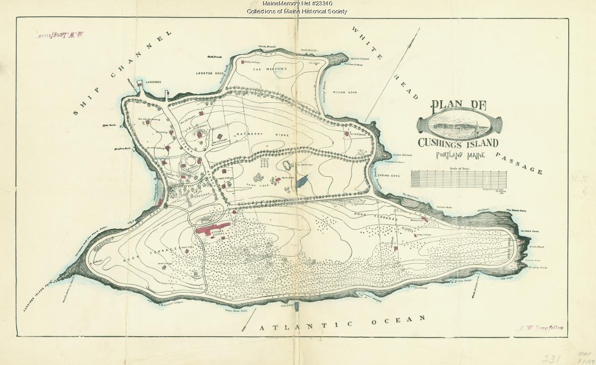
A. W. Longfellow's manuscript plan lays out the island's named features — Bayberry Ridge, Rock Terrace, the Meadows, Lobster Cove, Spring Cove, White Head. The road network of the summer island is being drawn before most of it is built.
[DOC]Source → - 1888Sold
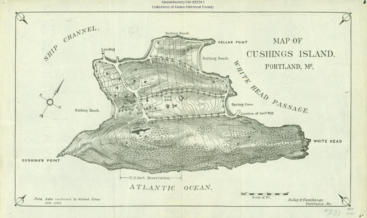
The Ilsley & Cummings lot map shows parcels already sold in dotted outline along the island's roads, and blocks out the southern shore for the United States Government. The avenue is now a property line as much as a route.
[DOC]Source → - 1917TransitionNo image held for this period
The Ottawa House burns. What the road served at its western end no longer exists; what it serves at its southern end — the fort — is expanding. No image of the avenue in this year is held here.
[DOC] - 1943Military landscapeNo image held for this period
The southern end of the island is a working coast-defense reservation. Whether the resort-era roads were regraded for military traffic, and where, is not established by any source in this history.
[POS] - TodayStill in useNo image held for this period
Sunken road cuts, stone walls parallel to grade, and long-worn shoulders. This history treats the road corridor as a layered feature: Wabanaki travel, colonial path, resort avenue and service route are not separable on the ground without excavation.
[HC]Stand here →
- 01Stand at Ottawa House GroundsPlace · Ottawa House Grounds — Resort · 1858–1917
- 02Look at the evidence: Ottawa House, Cushing IslandSource · Ottawa House, Cushing Island — ca. 1900 · Maine Memory Network / Maine Historical Society
- 03Who was John Calvin Stevens?Person · John Calvin Stevens — Portland architect; designed the island's Shingle-style cottages
- 04Open the case file: The Ottawa HouseCase file · The Ottawa House — Case file IV
- 05Stand at Steamboat Wharf & Ottawa LandingPlace · Steamboat Wharf & Ottawa Landing — Resort · 1858–1917
- 06Look at the evidence: Cushing Island, Portland HarborSource · Cushing Island, Portland Harbor — ca. 1870 · Maine Memory Network / Maine Historical Society